Herat Province
Appearance
Herat
هرات | |
|---|---|
 Scenery around the city of Herat | |
 Map of Afghanistan with Herat highlighted | |
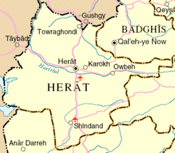
 Detail map of Herat province | |
| Coordinates (Capital): 34°00′N 62°00′E / 34.0°N 62.0°E | |
| Country | |
| Capital | Herat |
| Government | |
| • Governor | Noor Mohammad Islamjar[1] |
| • Deputy Governor | Abdul Qayyum Rohani |
| Area | |
| • Total | 55,868 km2 (21,571 sq mi) |
| Population (2021)[2] | |
| • Total | 3,780,000 |
| • Density | 68/km2 (180/sq mi) |
| Time zone | UTC+4:30 (Afghanistan Time) |
| ISO 3166 code | AF-HER |
| Main languages | only Persian |
Herat (Persian/Pashto: هرات) is one the 34 provinces of Afghanistan. It is in the south-western region of the country. The main city and capital is named Herat.
The region of Herat used to be part of Greater Khorasan. It was ruled by the Tahirids followed by the Saffarids, Samanids, Ghaznavids, Ghurids, Ilkhanates, Timurids, and Saffavids. In the early-18th century it became part of the Afghan Hotaki dynasty followed by the Durrani Empire.
Demographics
[change | change source]There are about 1,762,157 people living in Herat Province.[3]
Population by districts
[change | change source]There are 16 districts within the province. These are listed in the table below.

| District | Capital | Population (2006)[3] | Area[4] |
|---|---|---|---|
| Adraskan | 56,193 | ||
| Chishti Sharif | 25,428 | ||
| Farsi | 28,252 | ||
| Ghoryan | 90,201 | ||
| Gulran | 106,983 | ||
| Guzara | 135,187 | ||
| Herat (Capital) | 397,456 | ||
| Injil | 224,607 | ||
| Karukh | 58,594 | ||
| Kohsan | 57,782 | ||
| Kushk | 133,446 | ||
| Kushki Kuhna | 41,642 | ||
| Obe | 75,175 | ||
| Pashtun Zarghun | 90,817 | ||
| Shindand | 185,418 | ||
| Zinda Jan | 54,976 |
Sport
[change | change source]Football (soccer) is the popular sport in Herat Province. Cricket is also getting popular.
References
[change | change source]- ↑ "د هرات ولايت نوي والي او مرستیال والي معرفي او دندې یې پيل کړې – الاماره پښتو". Archived from the original on 2021-10-27. Retrieved 2022-10-29.
- ↑ "Estimated Population of Afghanistan 2021-22" (PDF). nsia.gov.af. National Statistic and Information Authority (NSIA). April 2021. Archived from the original (PDF) on June 24, 2021. Retrieved June 29, 2021.
- ↑ 3.0 3.1 "B. Demography and Population" (PDF). United Nations Assistance Mission in Afghanistan and Afghanistan Statistical Yearbook 2006, Central Statistics Office. Afghanistan's Ministry of Rural Rehabilitation and Development. Archived from the original (PDF) on 2012-03-21. Retrieved 2011-01-12.
- ↑ Afghanistan Geographic & Thematic Layers
